Everest Three Passes Trek Difficulty: How Hard Is It Really?
The Everest Three Passes Trek is widely considered one of the ultimate trekking adventures in the world. If you are wondering about Everest Three Passes Trek difficulty, it combines remote Himalayan wilderness, towering peaks, and three high mountain passes exceeding 5,000 meters.
If you are wondering how tough the journey truly is, the short answer is: it is exceptionally challenging. However, with proper physical preparation, adequate acclimatization, and a resilient mindset, it is entirely achievable for experienced trekkers.
Key Factors Contributing to the Difficulty
1. Extreme Altitude
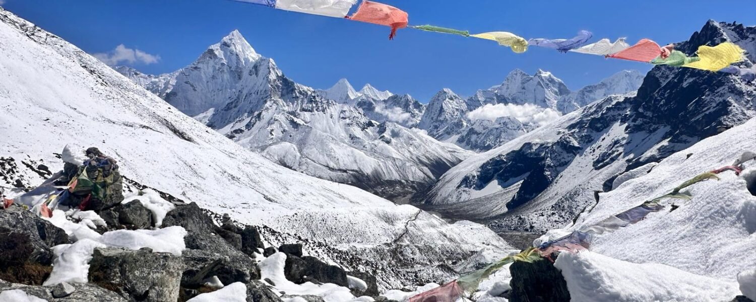
Altitude serves as the single greatest challenge on the Three Passes trek. You will cross three major passes—Renjo La (5,360m), Cho La (5,420m), and Kongma La Pass (5,535m)—alongside visits to Everest Base Camp (5,364m) and Kala Patthar (5,643m). At these elevations, the oxygen level drops to roughly half of what it is at sea level, increasing the risk of Acute Mountain Sickness (AMS).
2. Rugged Terrain and Long Walking Days
Unlike standard tea house treks that follow well-graded main trails, the Three Passes route features steep, rocky ascents, glacial moraines, and boulder fields. Consequently, you must expect to hike for 6 to 9 hours a day across uneven terrain, often enduring cold winds and fluctuating mountain weather.
3. Physical and Mental Stamina
The combination of continuous elevation gain, heavy daypacks, and consecutive high-altitude days pushes your physical endurance to the limit. Mental grit proves just as important as physical fitness, especially when navigating steep scree slopes or pushing through fatigue in freezing temperatures.
How to Prepare for the Three Passes Trek
Build Cardiovascular Endurance: Focus on running, cycling, or swimming at least 3 to 4 months before your trip.
Incorporate Strength Training: Build leg and core strength through squats, lunges, and weighted step-ups.
Practice Hiking with a Pack: Train on local hills carrying a 6 to 8 kg backpack to simulate trail conditions.
Prioritize Acclimatization: Never rush your ascent. Instead, follow a slow, methodical pace and allow buffer days for your body to adapt.
Summary Table: Trail Profile
| Parameter | Detail |
| Maximum Elevation | 5,535m (Kongma La Pass) / 5,643m (Kala Patthar) |
| Average Daily Walking | 6 to 9 hours |
| Trek Duration | 16 to 20 days |
| Fitness Level Required | Advanced / Excellent cardiovascular endurance |
| Previous Experience | Recommended (prior high-altitude trekking experience helps) |
Step-by-Step Counter-Clockwise Route Guide
1: Lukla to Phakding
Elevation: 2,840m (9,318ft) to 2,610m (8,563ft)
Trail & Difficulty: Easy to Moderate. After landing at Tenzing-Hillary Airport, the trail descends gently alongside the Dudh Koshi River. It features suspension bridges over roaring streams and well-graded stone steps, making it an ideal first-day warm-up.
2: Phakding to Namche Bazaar
Elevation: 2,610m (8,563ft) to 3,440m (11,286ft)
Trail & Difficulty: Moderately Difficult to Strenuous. The trail crosses multiple high suspension bridges (including the famous Hillary Suspension Bridge) before beginning a steep, relentless 2-to-3-hour uphill climb through pine forests to reach the vibrant trading hub of Namche Bazaar.
3: Namche Bazaar to Thame
Elevation: 3,440m (11,286ft) to 3,800m (12,467ft)
Trail & Difficulty: Moderate. Leaving the main Everest Base Camp Trek route behind, you head west along a quiet, winding trail carved into the hillside above the Bhote Koshi River. This stretch is culturally rich, featuring ancient monasteries, mani stones, and a gradual incline ideal for acclimatization.
4: Thame to Lungden
Elevation: 3,800m (12,467ft) to 4,380m (14,370ft)
Trail & Difficulty: Moderate to Challenging. The path follows the ancient trans-Himalayan salt-trade route deeper into the remote Bhote Koshi valley. The trail is wide and gradual, but the rising altitude makes the steady uphill push noticeably heavier on your lungs.
5: Lungden over Renjo La Pass to Gokyo Lake and Gokyo Ri
Elevation: 4,380m up to Renjo La Pass (5,360m) down to Gokyo Lake (4,750m) and up to Gokyo Ri (5,357m)
Trail & Difficulty: Strenuous and Technical. Climbing out of Lungden requires a grueling, steep ascent up a stone staircase to Renjo La Pass. After descending to the stunning turquoise Gokyo Lakes, climbing Gokyo Ri Trek terrain provides a steep, relentless 2-to-3-hour scramble rewarded with incredible panoramic views.
6: Gokyo Lake to Thangnak
Elevation: 4,750m (15,584ft) to 4,700m (15,420ft)
Trail & Difficulty: Moderate and Rugged. This is a relatively short trekking day, but it requires crossing the Ngozumpa Glacier—Nepal’s longest glacier. The trail winds through shifting moraine ridges, unstable rocks, and glacial ice debris, requiring careful footing.
7: Thangnak over Cho La Pass to Dzongla (Zong La)
Elevation: 4,700m up to Cho La Pass (5,420m) down to Dzongla (4,830m)
Trail & Difficulty: Highly Technical and Strenuous. Cho La stands out as one of the most demanding sections of the Everest Cho La Pass Trek. It involves a steep, rocky scramble up a boulder-strewn ridge followed by a cautious traverse across a hard-packed glacier section where microspikes or crampons are typically required.
8: Dzongla to Lobuche
Elevation: 4,830m (15,846ft) to 4,940m (16,207ft)
Trail & Difficulty: Moderate. A relatively short and scenic day follows a high contour trail that wraps around the hillside beneath the towering peaks of Cholatse and Lobuche, offering sweeping views down the Pheriche valley before rejoining the main trail at Lobuche.
9: Lobuche to Gorakshep and Everest Base Camp
Elevation: 4,940m up to Gorakshep (5,164m) and onward to Everest Base Camp (5,364m)
Trail & Difficulty: Strenuous. Walking from Lobuche to Gorakshep takes about 3 hours over rocky glacial moraine. After a quick break, you make the round-trip trek to Everest Base Camp across shifting, uneven glacier ice under severe high-altitude conditions.
10: Gorakshep to Kala Patthar and Back to Lobuche
Elevation: Gorakshep (5,164m) up to Kala Patthar (5,643m) and back down to Lobuche (4,940m)
Trail & Difficulty: Strenuous. The pre-dawn or sunset climb up Kala Patthar is a steep, relentless uphill push against freezing winds and thin air. After soaking in the ultimate view of Mount Everest, you retrace your steps down to Gorakshep and continue back to Lobuche for the night.
11: Lobuche over Kongma La Pass to Chhukung
Elevation: 4,940m up to Kongma La Pass (5,535m) down to Chhukung (4,730m)
Trail & Difficulty: Extreme and Technical. Kongma La marks the highest and most physically demanding of the passes. The trail crosses a vast, rugged expanse of loose moraine, steep scree slopes, and an icy glacial lake shore before plunging steeply down into the Imja Khola valley toward Chhukung.
Frequently Asked Questions: Difficulty of Everest Three Passes Trek (Clockwise Route)
Q1: What is the trail like from Namche to Thame and Lungden?
Answer: Leaving Namche Bazaar, the trail heads west toward Thame (3,800m / 12,467ft) along a quiet, winding path carved into the hillside above the Bhote Koshi River. Continuing onward to Lungden (4,380m / 14,370ft), the path follows an ancient trans-Himalayan salt-trade route. This section is wide, gradual, and culturally rich, providing a steady and manageable ascent ideal for early acclimatization.
Q2: How difficult is the crossing over Renjo La Pass?
Answer: Renjo La Pass stands at an elevation of 5,360 meters (17,585 feet). Climbing out of Lungden involves ascending a long, steep stone-staircase trail. While it is less technical than Cho La or Kongma La, the high altitude makes the continuous steps a rigorous and exhausting test of endurance.
Q3: What is the trek like from Gokyo Lake to Gokyo Ri and Thangnak?
Answer: After descending to the stunning turquoise Gokyo Lakes (4,750m / 15,584ft), climbing Gokyo Ri (5,357m / 17,575ft) is a steep, relentless 2-to-3-hour slog rewarded with incredible panoramic views. Afterward, moving from Gokyo toward Thangnak requires crossing the Ngozumpa Glacier—Nepal’s longest glacier—navigating unstable moraine ridges and glacial ice debris with careful footing.
Q4: How hard is the crossing over Cho La Pass?
Answer: Reaching 5,420 meters (17,782 feet), Cho La is famous for its technical nature. The trek from Thangnak to Dzongla (Zong La) requires navigating a steep, rocky ridge followed by a cautious traverse across a hard-packed glacier section where microspikes or crampons are typically required for safety.
Q5: What should I expect when staying in Lobuche?
Answer: Lobuche is located at 4,940 meters (16,207 feet) and functions as a major staging post on the circuit. Accommodations are basic and unheated, and because of the high elevation, temperatures drop significantly below freezing at night. Proper hydration and warm layers are essential here.
Q6: How difficult is the final push to Gorakshep?
Answer: Gorakshep is the final permanent settlement on the route, sitting at 5,164 meters (16,942 feet). The walk from Lobuche to Gorakshep takes about 2 to 3 hours and is physically draining due to the thinning air and uneven glacial moraine terrain.
Q7: Is the climb up Kala Patthar steep?
Answer: Yes, climbing Kala Patthar to 5,643 meters (18,514 feet) is a steep, relentless uphill push that usually takes around 2 hours from Gorakshep. Though short, the severe lack of oxygen makes it one of the most physically taxing parts of the trip, but it rewards you with the absolute best panoramic view of Mount Everest.
Q8: What is the trek like from Gorakshep to Everest Base Camp?
Answer: Trekking to Everest Base Camp Trek (5,364 meters / 17,598 feet) is not overly steep, but it is technically challenging. The trail winds across the rocky, shifting terrain of the Khumbu Glacier. Expect a round-trip duration of 4 to 6 hours navigating moraine ridges under high-altitude conditions.
Q9: How challenging is the crossing over Kongma La Pass?
Answer: Kongma La is the highest and most physically demanding of the three passes, reaching 5,535 meters (18,159 feet). The trek from Lobuche to Chhukung via Kongma La involves a rugged, steep ascent across loose moraine and an icy glacial lake shore. It requires excellent physical stamina and sure-footedness.
Q10: What is the altitude and difficulty of Chhukung?
Answer: Chhukung sits at an elevation of 4,730 meters (15,518 feet). When arriving from Kongma La, it serves as a welcome relief as you drop down into the Imja Khola valley. The descent from the pass is steep and challenging, but reaching Chhukung offers sweeping views of Lhotse and Ama Dablam and a chance for recovery.