Nepal Flash Flood 2026: Rasuwa and Bhotekoshi River Surge Update
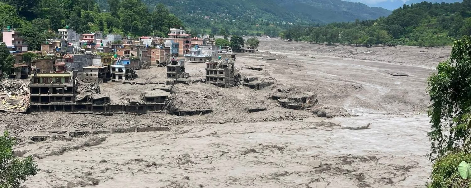
A sudden flash flood hit Rasuwa District on Wednesday, August 26, 2026. A strong wall of water rushed down the Bhotekoshi River valley without warning. The flood caused severe damage to local towns, border highways, bridges, and hydroelectric power plants in northern Nepal.
Local communities along the river suffered heavy losses. Rescue operations began quickly, but broken roads and destroyed bridges continue to slow down relief efforts.
Flash Flood Hits Rasuwa Valley Towns
The water surge struck key northern settlements in Rasuwa District. The most impacted towns include Timure, Syabrubesi, and Rasuwagadhi.
High water rushed through the river basin at high speed. The flood carried away rocks, mud, and heavy debris. It destroyed riverfront houses, shops, and temporary shelters.
Initial reports confirmed at least seven fatalities in the first few hours. Dozens of residents and workers remain missing. Local search-and-rescue teams saved more than 25 people on the first day. Search teams continue to look for missing people in isolated pockets along the river.
What Caused the Bhotekoshi River Surge?
Mountain experts and hydrologists are studying the cause of the sudden flood. Early reports show that a large ice avalanche fell high in the mountains. This ice block fell into the upper Lhende River and formed a natural dam.
The water built up behind the ice dam very quickly. Soon, the ice dam collapsed under heavy water pressure. This sudden break sent thousands of tons of water rushing downstream toward the Bhotekoshi River.
Heavy local rainfall and melting glaciers higher up may have made the flood worse. Because the ice dam broke far up in the mountains, downstream villages had almost no time to prepare or evacuate.
Heavy Damage to Roads, Bridges, and Power Plants
The surge severely broke important transport routes and energy facilities in Rasuwa:
Border Highway Damage: The road connecting Betrawati in Nuwakot to the Rasuwagadhi border crossing lost large sections to landslides and river erosion.
Bridge Collapses: The flood destroyed key motorable bridges. This completely stopped land trade and vehicular travel between Nepal and China.
Energy Disruptions: Flooded powerhouses and damaged intake dams temporarily knocked out 430 MW of hydropower. This caused power shortages across parts of the national grid.
Emergency Response and Rescue Efforts
The Government of Nepal responded quickly to the crisis. Security forces deployed personnel immediately to the flood zone, including:
The Nepali Army
The Armed Police Force
The Nepal Police
High-altitude rescue teams used helicopters to reach cut-off villages. Air crews dropped emergency medical supplies, food tents, and clean drinking water to stranded residents.
Rescue work remains difficult. Landslides have blocked main supply roads, and missing bridges make it hard for heavy machinery to enter the disaster zone.
Flood Warnings for Downstream River Villages
The Bhotekoshi River flows directly into the larger Trishuli River basin. Because of this, disaster management officials issued urgent safety alerts for towns further down the valley.
Districts placed on high alert include:
Nuwakot
Dhading
Gorkha
Chitwan
Authorities advised all riverfront residents to stay far away from the water. Emergency teams continue to monitor water gauges along the Trishuli River to predict sudden flow changes.
Impact on Tourism and Trekking in Rasuwa
Rasuwa is the main gateway for travelers visiting the famous Langtang region. Due to severe road damage near Syabrubesi, driving along the main Rasuwa road is temporarily paused. Road crews are working to rebuild bridges and clear landslide debris.
Trekkers planning to visit Langtang Valley should check current road conditions before traveling north from Kathmandu.
Status of Other Popular Trekking Regions in Nepal
While northern Rasuwa is fixing its transport roads, most other major trekking routes in Nepal are open, safe, and completely unaffected by the Bhotekoshi flood. Nepal features many distinct mountain regions that operate independently.
1. Everest Region (Khumbu Valley)
The Khumbu region sits far to the east of Rasuwa. All major trails are running normally:
Everest Base Camp Trek: The main route through Namche Bazaar, Tengboche, and Gorak Shep is fully open and safe.
Gokyo Lakes Trek: High-altitude lakes and pass crossings in the Gokyo Valley are operating without any disruption.
Three Passes Trek: Advanced circuit routes across Kongma La, Cho La, and Renjo La remain clear and accessible.
2. Annapurna Region
The Annapurna conservation area is located west of Rasuwa and operates on separate road and trail networks:
Annapurna Circuit Trek: The full circuit over Thorong La Pass remains open for trekkers.
Annapurna Base Camp Trek: The trail up the Modi Khola valley is safe and open.
Ghorepani Poon Hill Trek: Short foothill treks near Pokhara offer clear views and fully open lodge services.
3. Manaslu Circuit Trek
The Manaslu region sits between Annapurna and Ganesh Himal. The trail around Mount Manaslu is open for restricted-area group trekking. Travelers should double-check highway conditions along the Trishuli drive between Kathmandu and Machha Khola before departure.
4. Mustang and Remote Western Regions
Upper Mustang: The dry high-altitude desert trail north of Jomsom remains dry, fully accessible, and unaffected by monsoon flooding.
Dolpo Region: Upper and Lower Dolpo trails continue normal operations for wilderness trekking groups.
Travel Advice for Trekking in Nepal
If you have an upcoming trekking trip to Nepal, keep these key safety tips in mind:
Verify Road Access: Always ask your local trekking agency or guide for updated road reports before departing Kathmandu.
Follow Official Warnings: Respect instructions given by local police, army personnel, and park rangers.
Select Flexible Itineraries: If your planned route faces temporary delays, consider switching to unaffected regions like Everest, Annapurna, or Mustang.
Hire Licensed Local Guides: Local guides carry real-time updates regarding weather shifts, trail conditions, and lodge availability.
Frequently Asked Questions (FAQs)
What caused the 2026 Bhotekoshi River surge in Rasuwa?
Experts believe a high-altitude ice avalanche blocked the upper Lhende River, creating an ice dam that collapsed and released a heavy wall of water downstream.
Is the Langtang trekking route open right now?
The trails in the Langtang region are largely intact, but driving access between Kathmandu and Syabrubesi is temporarily limited due to road repairs in Rasuwa.
Are Everest and Annapurna treks affected by the flood?
No. The Everest and Annapurna regions sit in different river basins and are operating as normal.
Is overland travel between Nepal and China open at Rasuwagadhi?
Overland border trade at Rasuwagadhi is temporarily paused while crews rebuild damaged highway sections and border bridges.
Flood Warnings for Downstream River Villages” Section
Disaster management officials continue to monitor water levels along major river corridors. While operations near the upper Bhotekoshi remain on hold, travelers seeking adventure in unaffected areas can still safely explore popular river activities, such as White Water Rafting on designated downstream stretches or thrilling sports like Bungee Jumping at certified outdoor resorts.






Langtang Trek Route Update 2026: Alternative Route via Dhunche
[…] Trek Route, Langtang trekking route 2026, Langtang Valley Trek 2026, Syabrubesi Langtang Trek Previous Post Nepal Flash Flood Disaster 2026 Next Post Nepal Himalaya Base Camp […]